Image via Canva
— Quincy Massachusetts News by Quincy Quarry News – News, Opinion and Commentary.
A remote control snow blower
A file photo image
Snowfall locally on the order of ten to twenty inches is the working projection three days out from a storm that is expected to impact 200 million people from the Southwestern high deserts through middle of the Midwest and then northerly to New England with freeing rain to snow depending on where.
For example, Eastern Massachusetts is expected to be hit with very fluffy snow given temperatures in the low twenties. While expected to be light and thus easy to clear, any such fluffy snow over a foot of deep is not a day at the beach to clear.

“Trust me, i’m not lying: it’s going to snow.”
A still image from a YouTube video
The storm is expected to start early in the day on Sunday, peaking overnight Sunday night, and then lingering until Monday evening.
Needless to say, such will only make the start of the week trying at best.
Further, temperatures Monday night after the snowfall abates are expected to drop as low as ten degrees or thereabouts and so hard freezing any snow not cleared from where it needs to be.removed.
Even worse, daytime highs running in the twenties and single digits lows over night for the rest of the week along with light random snow events expected to add to the pain.
Shop early or Fuhgeddaboudit …
A Daily Mail image
Even worse, winds are expected to be more than sufficient to give rise to drifting of the expected high fluff snow.
In turn, there is every likelihood that the snowfall will be the most suffered locally in years.
Needless to say, locals are out of practice dealing with merely but a middling snowfall.
Even so, grocery stores are already seeing an uptick of people laying in food what with the Universal Hub’s French Toast snow storm alert is at four slices and thus but one short of snowmageddon.
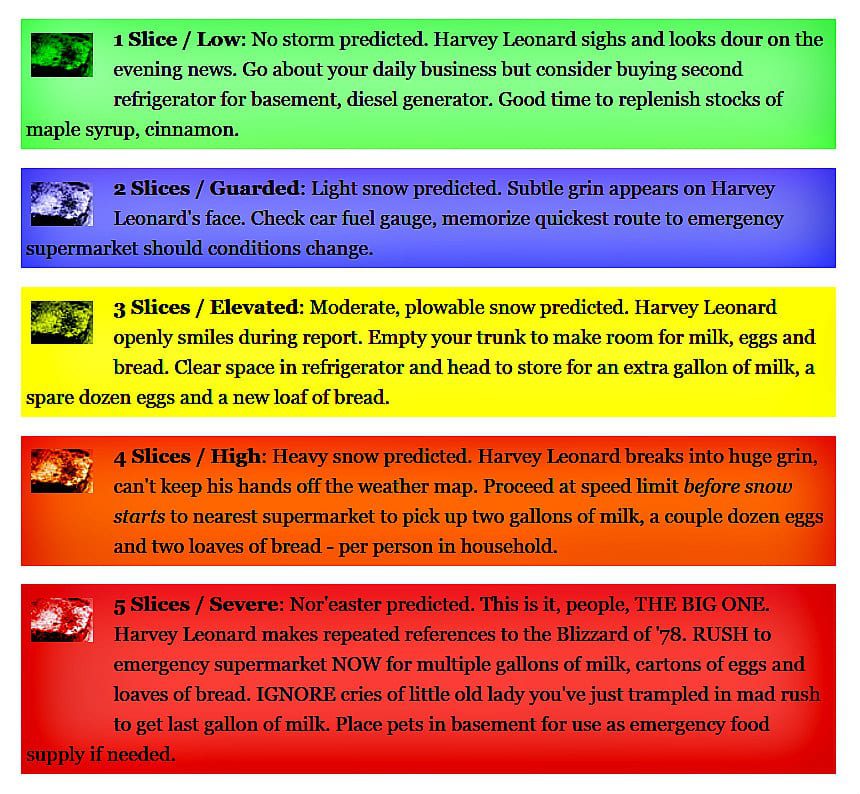
A Universal Hub graphic


I object.
Objection sustained
This storm is surely over Graz’s head. Let’s see how many plows and manhole covers we can destroy during this storm.
I just want it to be known that I co-sponsored this comment, and want to let the public know and put this into the record.
And water valve covers — don’t forget water valve covers!
Gotta love the mayor on channel 25 news talking about the potential cost of the cleanup not being budgeted. Then saying the state allows cities and town to spend anyways. Then he says “we’ll worry about the budget later.”
Duh. Nothing makes Tommy’s day more than no spending limits imposed on him.
Here we go — the mayor had his army of supporters/employees hitting the streets on overtime placing fake tickets on cars. Talk about overkill, between the text messages, emails, phone calls and media exposure seems like message heard. Fake tickets a waste of resources, we live in New England and it snows. BTW, I did put mine in the recycle to help save the planet, the one Koch is not on.
Watch how Koch runs up the snow cleaning costs beyond what is truly needed. He will let his donating contractor’ buddies charge the city for services that in the end were not required. Watch the donator list on the OCPF website in the months ahead, the contractors will be cutting some of their takes back to Koch with taxpayers so fleeced yet again.
Will Noel DiBona object to the excess spending? NOT! Koch will instruct him how to vote and then he will go missing again.
Maybe I missed something but I didn’t see much in the way of brining or salting pre-storm.
Duh — the Patriots were playing in the early NFL Conference Championship game yesterday.
Brining is customarily done BEFORE a storm.